Dive Site Maps for Australia: 3D Terrain, Reef Trails and Underwater Navigation
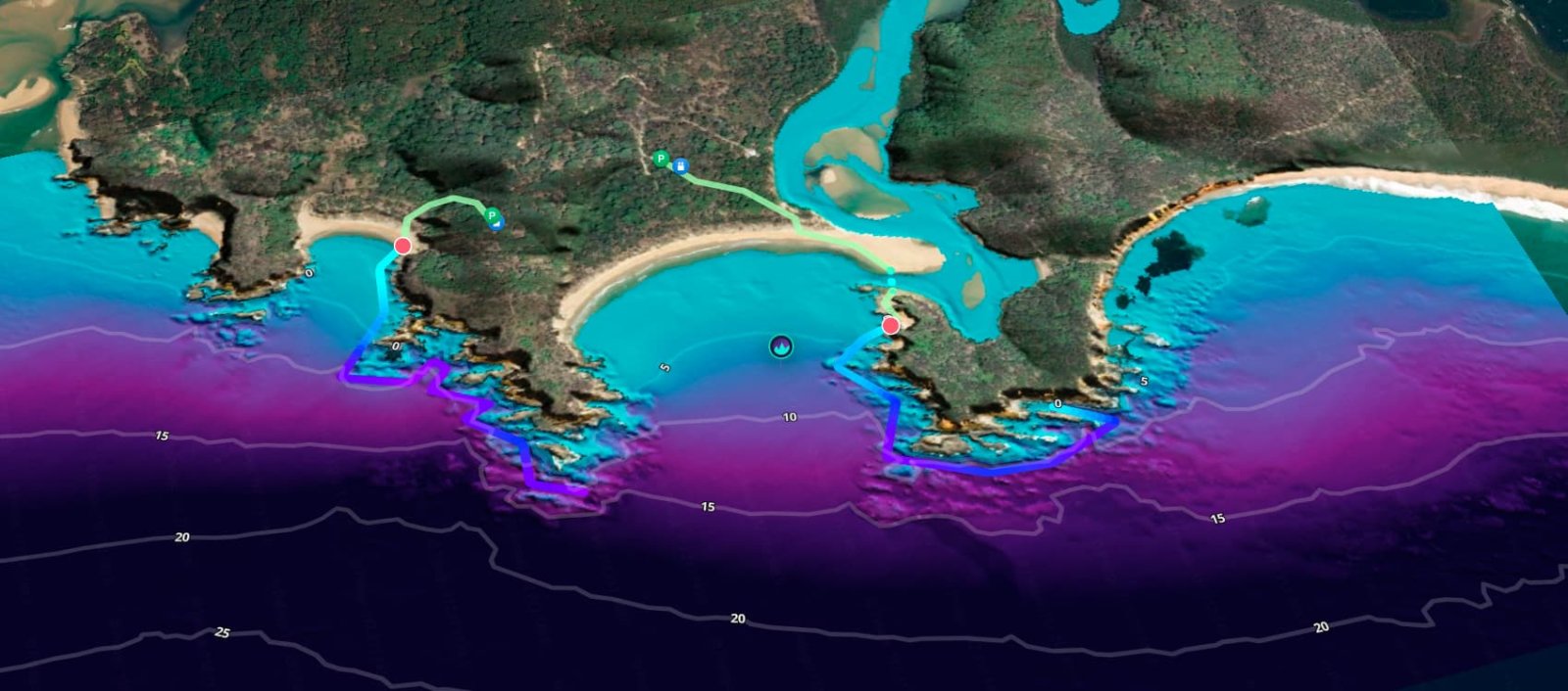
It's first light in a car park above the water. Wetsuit half on, phone in hand. The pin says the site is somewhere down there. It doesn't say which stairs, which rock, or which line of reef leads to the wall the regulars keep talking about.
Most dive site maps stop at the pin. Pelagic's dive site maps start there, and they keep going: from your front door to the best parking, down the trail to the exact entry point, and out along the reef once you're in the water.
At a glance
- Coverage: hundreds of dive sites mapped across Australia, with global expansion underway
- Door to water: turn-by-turn directions to the best parking, then the trail to the entry point
- Underwater: depth contours, reef relief, Reef Trails and marine life hotspots
- In 3D: Echo³ terrain models of popular sites
- New this October: Reef Navigator, underwater guidance without GPS
- Access: invite-only, by waitlist request
Dive Site Maps Across Australia: Hundreds of Sites Mapped
Pelagic has mapped hundreds of dive sites across Australia. Shore dives, boat dives, reefs, walls, pinnacles. The entry points are exact instead of "roughly here".
Sydney was first, and it's where the detail runs deepest. The same mapping is now moving up and down the coast, and global expansion is already underway.
Hand-Mapped Dive Site Maps From Our Own Surveys
Every Pelagic map is hand-mapped from our own in-house surveys. Our maps and survey data aren't scraped from other sites, and they aren't made up by AI. We survey on the ground, at the dive sites, in person.
We're now on our fifth survey expedition, mapping dive sites first and the reefs around them in both 2D and 3D, in more detail than before. Thanks to everyone backing the work, global expansion is already underway.
Why Most Dive Site Maps Only Get You Halfway
A pin tells you where the car park is, near enough. A flat drawing tells you there's reef somewhere out the front. Neither tells you where the wall starts, which gutter holds the fish, or how to get from the sand to the good part of the site without diving laps of the wrong bit.
So the first dive on a new site goes to navigating. Half your attention is on finding your way and the other half is on not wasting air. The best of the site, the ledge, the bommie, the gutter where the sharks sit, tends to turn up on dive five.
That's the gap we built Pelagic to close. Not a vague idea of where to go before you get wet. The exact place, with no ambiguity, and then a guide for the dive itself.
Dive Site Navigation From Your Front Door to the Water
Pelagic maps the whole path.
- Front door to parking. Turn-by-turn navigation to the best parking for the site, one tap to open it in your phone's maps.
- Parking to entry point. A trail from the car to the exact place you get in, so you're not guessing between three tracks and a fence.
- Facilities and fees. Where the toilets are, whether you'll pay for parking, whether the walk is two minutes or twenty.
None of it is glamorous, and all of it matters at 6am with a full set of gear. Pelagic handles the maps and the navigation so you can save your attention for the dive.
Depth Contours and Reef Relief Maps
Once you're at the water's edge, the map turns from roads to reef.
Depth contours show the shape of the site from above: where the bottom shelves gently, where it steps down, where it falls away. You can read the difference between a sandy slope and a wall before you've put a fin on.
Reef relief maps go further. They shade the reef by depth, so a ridge looks like a ridge and a gutter looks like a gutter. At a glance you can see where the structure is and how deep it runs.
Reef Trails: The Route to the Best Parts of the Reef
A site can be a kilometre of reef and only ten minutes of it is the reason people come back.
Reef Trails map the route through the good parts. Follow the trail and it takes you along the structure to the features worth the air: the wall, the overhang, the pinnacle that only the locals know. It's the short list a local dive buddy would give you, drawn on the map.
Marine Life Hotspots and Must-See Locations
Divers don't just want to find a site. They want to find the animals.
Marine life hotspots mark where divers reliably see things at each popular site, from grey nurse sharks at Magic Point to the ledges and gutters where fish gather. Pair them with a Reef Trail and you can plan a dive that passes the must-see spots in a sensible order, instead of finding out about them on the boat ride home.
One honest note. A hotspot is where your odds are best, not a promise. Animals move, seasons change, and some days the water has other plans. We'd rather tell you that than overpromise.
3D Dive Site Maps: Seeing the Seafloor With Echo³
Echo³ gives you a bird's-eye view of your favourite dive sites in full 3D. The seafloor terrain is the real terrain, rendered in high definition.
To be precise, Echo³ is a 3D model rather than a flat map. Spin it, tilt it, drop in close to a wall and look along it. You see where each ridge, gutter and drop-off sits relative to the others, and where you'd want to be at each point of the dive.
This is the difference between a map that gives you a rough idea and one that shows you exactly where each geographical feature of the site is. Echo³ is available at popular sites, with more being added region by region.
Build Your Own Dive Route
Seeing a site in 3D is exciting. Drawing your own route across it is better.
Pick your entry point, pick the feature you want, and draw the line. Pelagic gives you the bearing, the distance and the reciprocal for the dive back. Plan a route to the pinnacle, around the wall and home again, and take the guidance with you into the water.
This is diving intelligence: the plan, the terrain and the route in one place, built before you get wet.
Underwater Navigation Without GPS: Meet Reef Navigator
GPS stops working the moment you go under. Satellite signals don't make it through the water, which is why underwater navigation has always come down to a compass, a plan and your own judgement.
This October, Pelagic's maps get something new. Reef Navigator is your own underwater guide, working turn by turn along Pelagic's Reef Trails. It tells you where you are on the trail, segment by segment, and what's next: which way to head and which part of the reef you're diving to. It works without GPS.
The point is simple. You dive to the best parts of the reef without doing the sums mid-dive, and you always know which leg of the trail you're on.
What No Dive Site Map Can Do
A map is a plan. Conditions decide the day.
Swell direction, surge, visibility and boat traffic change what a site is like from one weekend to the next, and some sites are simply bad in the wrong conditions. Check the forecast before you commit. Pelagic's conditions forecasts and visibility predictions sit right next to the maps for this reason.
And Reef Navigator or not, carry your compass and gauges, dive within your training, and stay with your buddy. The map helps you plan. It doesn't replace any of that.
Dive Site Maps FAQ
What is the best way to find dive sites in Australia?
Look for a map that gives you exact entry points, parking and a route to the good parts of the reef, not just a pin. That's what Pelagic's dive site maps are built around.
Can dive site maps work without GPS?
Not underwater, nothing does. Pelagic's Reef Navigator gets around this by guiding you segment by segment along a Reef Trail and showing where you are on it, with no GPS needed.
Does Pelagic have 3D dive site maps?
Yes. Echo³ is a 3D terrain model of popular dive sites, showing the seafloor in high definition. It's part of Pelagic Pro.
Can I sign up to Pelagic today?
Pelagic is invite-only at the moment. You can request an invite through the waitlist.
See the Whole Dive Before You Get Wet
Pelagic handles the maps and the navigation, from your front door to the pinnacle that only the locals know. You just enjoy the dive.
This is diving intelligence. This is Pelagic.
Pelagic is currently invite-only. We keep an eye on who's genuinely interested, so a quick note about yourself goes a long way.