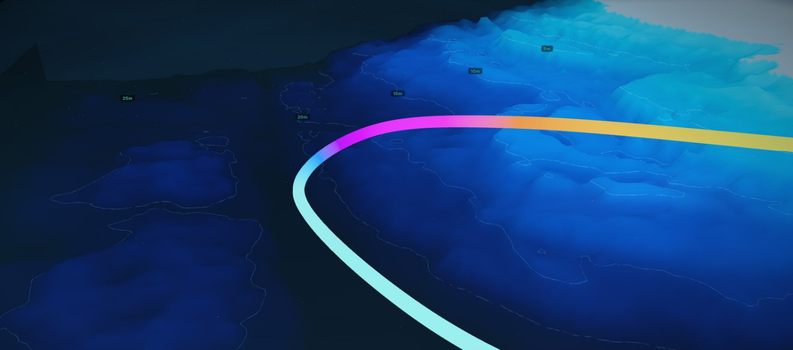
Echo³ is now live on Pelagic Pro. Starting today, select dive sites across the NSW coast have fully interactive 3D terrain models — accurate representations of the actual seafloor — that you can explore in your browser before you ever gear up. Coverage spans Sydney and beyond, with more sites being added continuously.
Most divers plan from a two-dimensional map. A pin on a satellite image, maybe a hand-drawn sketch in a dive guide, a description that says "follow the wall east." You enter the water with a rough idea and the site reveals itself with limited visibility as you go. For familiar sites that's fine — until it isn't. A poorly understood site is a less safe and less interesting dive.
Echo³ is the fix for that. It allows you to see the entire terrain, with 3D reef trails for finding the best places at any supported site. Orbit the entire reef, fly along the wall, read drop-offs from any angle, and tap anywhere on the terrain to get the exact depth at that point. It's the most detailed interactive 3D model of a dive site available to recreational divers in Australia — and nothing else like it exists.
A standard dive map tells you where things are. It doesn't tell you what they look like in three dimensions — how steep the wall is, how far the sand flat extends before the reef starts, or whether a drop-off is a gradual slope or a sheer vertical face. For a sport where spatial awareness determines both safety and enjoyment, planning from a flat image is a significant constraint.
A 3D dive site map changes that entirely. The difference becomes obvious the first time you open a familiar NSW dive site in Echo³. A dive you've done twenty times looks different when you can orbit the full underwater terrain, see the relationship between the entry point and the first reef structure, and trace your planned route through real space. You notice things a flat map obscures — the secondary drop-off behind the main wall, the sand gutter connecting two reef sections, the shallow platform that makes a good safety stop on the way back.
For a dive site you've never visited, the value is even greater. Walking through an interactive 3D dive map before your first dive is the closest thing to a local briefing you can get without actually knowing a local.
Yes — the terrain is real. The seafloor you're looking at in Echo³ reflects actual depths and contours at that site. The walls are where the walls are. The drop-offs are at the depths they're at. The sand flats, the gutters, the reef structure — it's not an artist's impression or an approximation. What you see in Echo³ is what you'll find when you descend.
The colour gradient maps directly to depth — aqua in the shallows, deepening through blue-green into dark indigo at the bottom. Depth contour lines run at 5-metre intervals across the terrain, making it easy to read reef shape and identify walls, drop-offs, and plateaus at a glance. For sites with gently sloping topography, a vertical exaggeration slider lets you amplify the terrain height so subtle features become clearly readable.
Open any supported dive site on the Pelagic map. Sites with a 3D terrain model show an Echo³ button floating above the site marker — tap it and the 3D viewer opens in a new tab, loading the terrain within a few seconds.
The scene opens with a cinematic camera animation orbiting the full site so you can immediately read the overall seafloor shape. From there you're in full manual control:
The compass in the top-left rotates with your view so you always know your heading relative to the actual site. Use it to find north, confirm the wall direction, and match what you see in Echo³ to what you'll see once you're underwater.
For dive planning, a simple workflow covers most sites: load the 3D map, orbit to read the overall terrain shape, switch on Reef Trails, trace your intended route, use the measure tool to check key distances, and note any POIs you want to find. Five minutes in Echo³ and you'll know the site better than most people who've dived it once.
Reef Trails — the turn-by-turn underwater routes available on the Pelagic 2D map — are overlaid directly onto the 3D terrain in Echo³. The trail tubes sit on the actual seafloor geometry, following reef structure, dropping down walls, and tracing along sand channels. You can see exactly how a route moves through space before you descend.
"I opened Magic Point in Echo³ before my first dive there. I knew exactly where the gutters were, how deep the shark aggregation area sat, and where to turn around. It's the first time I've dived a new site and felt like I already knew it." — Pelagic Pro member, Sydney
The Steps at Kurnell is a useful example. On the 2D dive map, the reef trail appears as a coloured line heading east from the entry. In Echo³ you can see what that means in space — a route that tracks along a rocky ledge before dropping onto a sand flat, then climbs back onto the reef as it hooks south. The weedy seadragon hotspot marked at around 8m sits on a specific rocky outcrop that's immediately identifiable on the 3D terrain. You could spend ten minutes searching for it underwater on a first visit; in Echo³ you find it in thirty seconds.
The Leap , immediately south of The Steps, shows the same value from the opposite angle. It's a deeper, more exposed Sydney shore dive, and the 3D map makes immediately clear why. The reef drops steeply from the entry platform, the wall to the east is sheer, and the sand channel connecting back to the exit runs deeper than a 2D map suggests. Knowing that before you enter the water is the difference between a planned dive and a discovery dive.
Trail colours use the same depth coding as the 2D map — aqua for 0–5m through to deep indigo at 30m+. On the 3D terrain this becomes intuitive fast: the colour shift and the physical seafloor shape confirm each other. Surface swim sections render as floating tubes above the water plane, clearly separating above-water transit from the underwater portion of the dive.
You can customise what's displayed using the overlay settings panel — toggle pins, trails, waypoints, compass bearing arrows, and per-segment depth labels on or off independently. The panel also shows a depth profile graph for each trail: a quick elevation cross-section of the route so you can see exactly how the depth changes across the dive before you're in the water.
Tap the ruler icon and Echo³ enters measure mode. Each click or tap drops a pin on the terrain and draws a segment showing horizontal distance in metres and compass bearing to the next pin. A running total accumulates as you go.
The distances are real — the terrain is built to accurate real-world dimensions, so 80m in the measure tool is 80m in the water. Use it to confirm the swim from entry to the wall, check that a third-of-air turnaround works for your intended route, or measure the surface swim from Shelly Beach out to the edge of Cabbage Tree Bay before you decide whether conditions are good enough to push further.
Beyond manual orbit, Echo³ includes four cinematic camera moves — accessible via the camera icon in the bottom-left controls:
Fly Trail is the standout. Select any reef trail and the camera locks onto it, gliding along the seafloor geometry at dive speed. It's the closest thing to previewing the actual dive without getting wet — and for a new site, it's genuinely useful for building spatial memory before you enter the water.
Every pin type from the 2D Reef Trails appears on the 3D terrain — entry points, exit points, points of interest, and hazard markers — each at its correct position on the seafloor. Tap any pin to open the same description you'd see on the 2D map.
The difference in Echo³ is context. A POI at 18m on a sheer wall means something different to a POI at 18m on a gradual slope — and now you know which one before you descend, so you can plan your gas and turnaround point accordingly.
NSW dive sites currently live in Echo³ include:
Echo³ is available on select popular dive sites across the NSW coast — concentrated in Sydney but extending north and south along the coastline. The Echo³ button appears on the Pelagic map only where a 3D model exists, so it's always clear which sites are covered. If you don't see it on a site you dive regularly, it's in the pipeline.
New terrain models are added continuously, prioritised by dive frequency and bathymetric data availability. Jervis Bay is a priority region for upcoming coverage, along with the Mornington Peninsula.
The best dive is a planned dive — not planned in the obsessive sense, but planned in the sense that you know the terrain, you know where the features are, and you're not spending the first half of your bottom time orienting yourself.
Echo³ is live today on Pelagic Pro, covering select popular dive sites across the NSW coast with more being added continuously. Open any supported site on the Pelagic map, tap the Echo³ button, and you're in. It takes about thirty seconds to load and five minutes to know the site better than most people who've dived it once.
Pro also includes visibility forecasts, Smart Dive Trails, live check-ins, and the full 7-day conditions forecast for every site.